
Previous / Next: Location / David Robinson
See also: Howth Census data | Environmental data | Howth maps through the ages | Major Shipwrecks around Ireland
A brief history of Howth, Co. Dublin
Early times
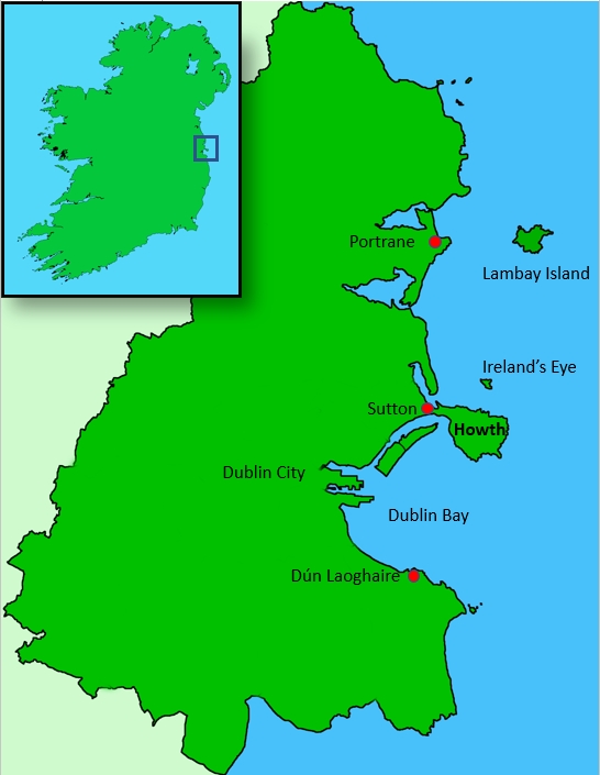
Around 3000 BC, Howth was an island, inhabited by a few settlers, and was close to the other local islands of Lambay and Ireland's Eye. Soon, Howth became connected to mainland Ireland by a sandy isthmus at Sutton cross, and became a peninsula.
Vikings - Lambay Island, Ireland's Eye and Howth
When the Vikings came to Ireland in 795, one of the first areas to be attacked were Lambay Island, Ireland's Eye and Howth.
Lambay had originally been called Rachra. The only indirect reference to the old name today is in the town of Portrane (originally Port-Rachrann) which would have been the nearest mainland town to the island. However, after the Vikings arrived, they named the island 'lamb oy' or 'island of lambs' due to the tradition of sending mainland sheep over to the island to wean in the spring.
Ireland's Eye was originally called Inish Nessan (Nessan's Island) after a local saint called Nessan. When another woman took over the island, it became 'Inish Eria' (Eria's Island) and when the Vikings arrived, they called it 'Eria's Oy'. Over time, this became Eria's Eye. Then a 16th Century map maker incorrectly wrote it as 'Erin's Eye', which subsequently became 'Ireland's Eye'.[2] [16]
The name Howth is thought to be of Norse origin, perhaps being derived from the Old Norse Hǫfuð ("head" in English). Norse Vikings colonised the eastern shores of Ireland and built the settlement of Dublin as a strategic base between Scandinavia and the Mediterranean.
After Brian Ború, the High King of Ireland, defeated the Norse in 1014, many Norse fled to Howth to regroup and remained a force until their final defeat in Fingal in the middle of the 11th century. Howth still remained under the control of Irish and localised Norse forces until the invasion of Ireland by the Anglo-Normans in 1169.
Without the support of either the Irish or Scandinavian powers, Howth was isolated and fell to the Normans in 1177. One of the victorious Normans, Armoricus (or Almeric) Tristram, was granted much of the land between the village and Sutton. [1]
Armoricus built his first castle near Howth harbour and was the first of many Lords, Barons and Earls of Howth. He took the name St. Lawrence in honour of the Saint's day of August 10th, and created a dynasty that would last for centuries.
The various generations of St. Lawrence's held a firm view on what the lands of Howth were used for. Some would argue that, generally, this was good thing as it stopped Howth from being abused in terms of inappropriate housing or development. [2] [16]
Howth before the 18th century
From very early days, merchants would mostly come to Howth by sea to sell and barter for their goods. Being a fishing village, the main 'currency' would have been herring. This is reflected in the name of the beach area east of Howth harbour called Balscadden which is named after a village in north Dublin, and means 'the town of the Herring'. [5] [9]
This dependence upon sea trade with Dublin didn't change much under British rule for Howth. At the same time, during this period, the role of Dublin itself was growing. In fact, Dublin was often thought of as the second city of the British Empire. [20] Therefore, communications between London and Dublin remained important, with sea transportation being a crucial link in the chain.
In this communications chain, the nearest port in Great Britain to Dublin was Holyhead. However, Dublin bay and port were exposed to the vagaries of the weather, and shipwrecks were common. During very stormy periods, it had been known for sailing ships to not be able to reach Dublin city port for several weeks at a time. [3]
This had helped Howth to become an important port from at least the 14th century onwards, trading mostly with England, and exporting goods such as corn and hides. In Elizabethan times, due partly to the problems of getting in and out of Dublin port, Howth became one of the largest towns in the Dublin area with the harbour being mostly used for passenger traffic. People sailing from Holyhead would often disembark at Howth and travel by horse and carriage into Dublin, rather than risk the sea journey into Dublin port.[3]
Dublin also relied upon Howth to supply the majority of its herring, which was an important source of food back then. However, by the 18th century, traffic to England had diminished as Howth was often seen as just a little too remote from Dublin.
One of the few aspects of trade that did continue in Howth, though, was smuggling. With its rocky shore and many caves, Howth was a great hiding place for contraband goods, many of which came from some of the shipwrecks around the bay.[3]
The 18th century
With a view to making Dublin a safer port, back in 1716, a project to build a bank to protect the south side of Dublin harbour was started. This bank had limited success and was later replaced in 1753 with a wall called the South Bull Wall. [22]
The first harbour at Dunleary (now Dún Laoghaire) was built in 1767 as both a port for transferring passengers to Dublin in poor weather conditions and as a safe harbour for ships to take refuge from the storms. [21]
During this period, many Dublin merchants were unhappy with how the port was being run and in 1786 the control of the port was handed over to a new merchant-controlled body called the Ballast Board, who also took over the control of Dunleary harbour.
Trade to and from Dublin expanded during the 18th Century with cargos of linen and agricultural produce being sent to Britain and the Commonwealth. In return, the ships brought coal and many luxury goods to the wealthy merchants and Parliamentarians living in the luxurious Georgian houses that had sprung up during this period in Dublin.
As the trade expanded, so did the size of the ships. Unfortunately, a constant build up of silt and sand in Dublin harbour stopped many of the larger ships from docking, and they had to unload their cargo onto smaller vessels at places like Ringsend, for onward travel into Dublin. [22]
The 19th Century
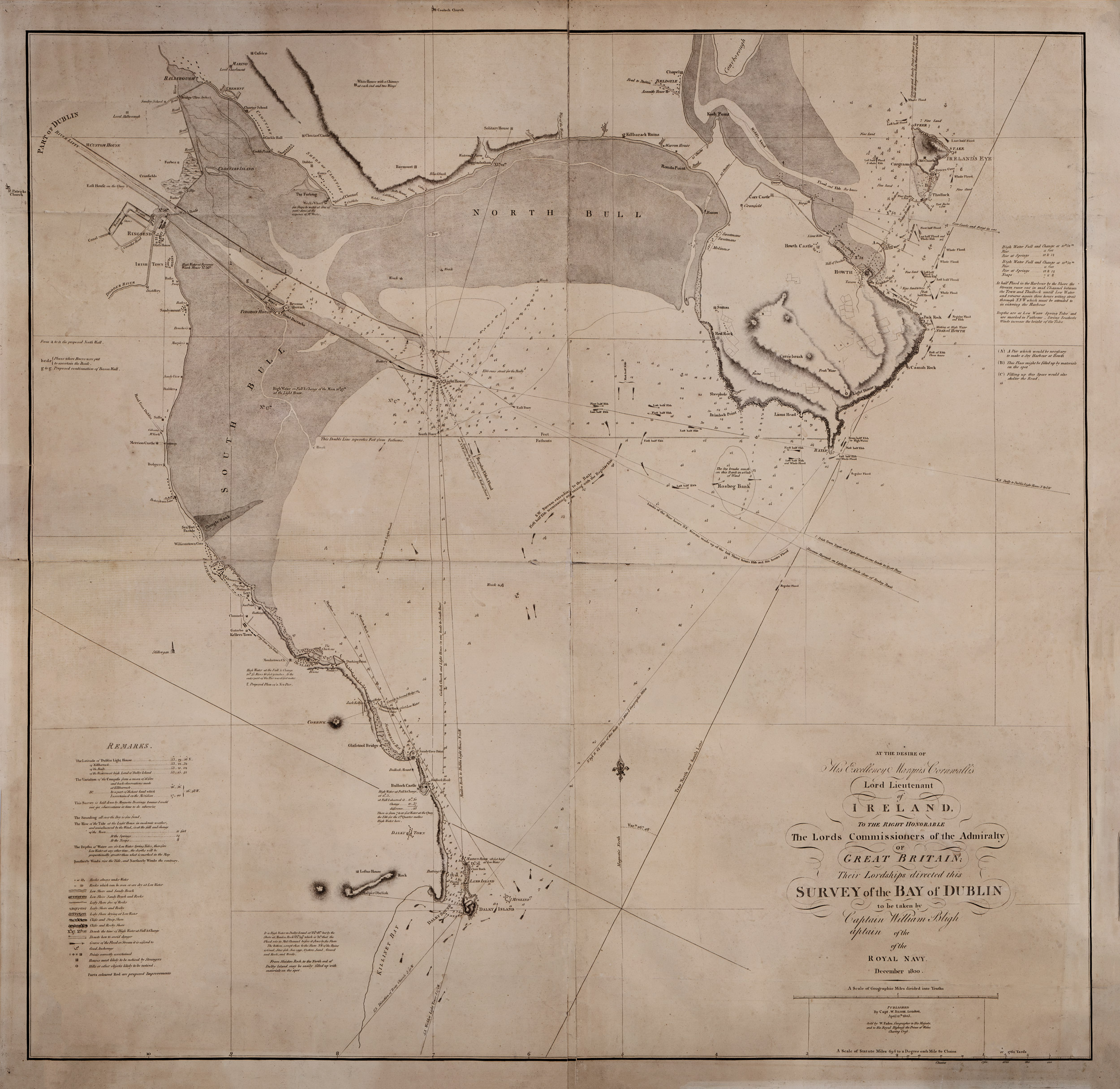
To ascertain what could be done to prevent this constant silting from happening, a major survey of Dublin harbour was commissioned by the Ballast Board in 1801, led by Captain William Bligh (of the Mutiny on the Bounty fame). He recommended the building of a parallel wall to the South Bull Wall to allow the natural tidal effects created by the two walls to deepen the harbour. This new North Bull Wall did eventually do exactly that, resulting in a new Bull Island being created north of the harbour from all of the silt deposits.
However, these results took 48 years to take effect. In the meantime, ships were being wrecked and lives lost. A solution was needed sooner.
The Acts of Union 1801 - the Mail Packet and Howth Harbour
Under British rule, Ireland had its own Parliament up until 1800. This had brought much wealth to the country with fine houses being built and architectural advances being made in Dublin city.
However, there had been talk of a union between Great Britain and Ireland since the mid 1700s. The Irish Rebellion of 1798 brought that to a head, and resulted in the Acts of Union, which came into force in 1801. These acts dissolved the Irish parliament and centralised all governing powers in England. This meant that over 100 Irish parliamentarians now needed to travel regularly to the Houses of Parliament in London, and communication links from London to Dublin became more important than ever. [17]
Dublin to London travel and communications
Traveling from Dublin to London in the early part of the 19th century was a slow and perilous journey. Travel would have been by coach, horse, sailing boat, and by foot on roads that were often rough at best. Journey times between the two cities could be up to two weeks, with many dangers on the way, including robbers on land, and stormy seas that wrecked boats and ships, and took many a life. [19]
In 1807, two troop ships, departing from Dublin, were driven on to the rocks between Blackrock and Dunleary by a storm, with a loss of over 400 lives. This disaster gave rise to a project to create what was known as an 'asylum harbour' where ships could take refuge during storms. The competition for this harbour was between Howth and Dunleary.
However, the British Government also needed to find a suitable harbour on the Irish side for the all-important mail packet (postal service) and for transporting people to and from Holyhead.
The initial two port choices in Dublin were Howth and a proposed harbour at Dalkey on the Southside of the city.
The arguments for choosing Howth were outlined in a series of pamphlets written by the superintendent of the Howth lighthouse, and a local clergyman, and presented to the Ballast Board. The first argument was that Howth was closer to Holyhead than Dalkey. The average sailing time taken from Dublin to Holyhead was 17 hours 7 minutes. The move to Howth reduced this to about 15 hours. [10]
The second argument for Howth was that a shorter pier would be needed at Howth and that the area could be guarded easily from attacks by enemies. They also argued that a larger harbour at Howth could increase the amount of fish they could land, thus improving the diet of Dublin people.
One of the arguments used against Howth was that coaches were often robbed at Sutton as they tried to exit the Howth peninsula (at that time Sutton was open countryside.) [1]
However, once all the arguments had been heard, the costs for both proposals at Howth and Dalkey were compared, and Howth proved to be the cheaper option. The Ballast Board therefore chose Howth.
.jpg)
Work began on the new Howth harbour in 1807 with the building of the East Pier. However, after part of the new pier collapsed, the great Scottish civil engineer, John Rennie, took over and he later took on some responsibility for ensuring that the project was finished. [3]
The harbour was completed in 1813. The first mail packet boat, called the Escape sailed out of the new harbour at Howth in 1816, with the official service starting on 1st August 1818. [2] [3] [23]
Business was good and the increasing passenger numbers resulted in the building of a number of hotels in Howth, including the Royal Hotel (later renamed the Baily Court), the St. Lawrence, Claremont Lodge (later renamed to Howth Lodge), the Marine at Sutton, and the Deerpark. Out of all of these, only the Marine is still open today (although there is talk of the Deerpark re-opening). [5]
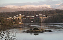
Over in Great Britain, a Scottish civil engineer, Thomas Telford, won the contract to construct the road from London to Holyhead, including the design and build of the Menai Suspension Bridge on the island of Anglesey in Wales.. However, over in Ireland, the Irish Parliamentarians complained about the poor state of the road from Howth to Dublin. After debate in Parliament, it was agreed to extend Telford's contract and include the Howth Road in Dublin. [18]
Telford's new roads in Britain and Ireland, along with the new harbour turned out to be the largest road building project since Roman times. [19]
In 1822, Steam ships started using Howth harbour, reducing the time to get to Holyhead from 15 hours to less than 6 hours. [5] However, the new steam ships got bigger and the harbour was starting to silt up. It soon became increasingly difficult for some of the new ships to get into Howth. As a result some of them moved to Dunleary in 1826.
Dunleary fights back
In 1817, the building of the new harbour at Dunleary was started and was soon to rival Howth, especially as the silting problems in Howth were starting to emerge. King George IV visited the new port in 1821, and Dunleary was renamed Kingstown, a name it would have until 1920.
As the silting became worse at Howth, more of the mail packets were transferred to Kingstown. Eventually it was decided that, despite the amount of money invested in Howth harbour, the regular dredging was turning out to be too costly, and, on 22nd January 1834, the complete operation of the packet was transferred to Kingstown. [1]
The rise of the railway
With the transfer of the mail boat to Kingstown came the building of Ireland's first passenger railway from Dublin (Westland Row station) to Kingstown, which was opened on 17th December 1834. This was followed in May 1844 by a service from Dublin to Drogheda opened by the Dublin and Drogheda Railway company.
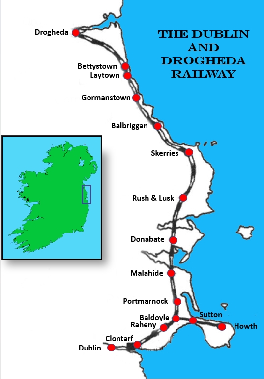
Despite Howth losing out to Kingstown for the mail boats, it was decided to build a branch from the newly built Dublin to Drogheda line out to Howth harbour. [5] [9] This may have been the first passenger railway in Howth, but it wasn't the first railway there. It is thought that some form of railway was used during the construction of the new harbour in Howth. [19]
However, the mail boat never returned to Howth and without the mail packet service, Howth was soon by-passed by regular sea traffic to Holyhead and it looked like it was to return to being a sleepy fishing village. [5]
Notwithstanding the loss of the mail boat, the branch railway line was completed and the first passenger train arrived in Howth on the 30th May 1847.
Howth as a tourist attraction
After the packet left for Kingstown, Howth was left with a beautiful new harbour. Although it could not accommodate large steam ships, it was still deep enough for fishing boats and the fishing heritage of Howth continued, especially for Herring. This peaked in the late 1870s when up to 1,000 herring boats were counted in the harbour.
Despite the lack of the mail boat, the building of the harbour had caused a lot of interest in visiting Howth. And now with the railway going there, tourism started to take off.
One of the main tourist attractions for Howth was bathing, which was presumed to have noteworthy healing powers. in fact, one of the first tenants in Earlscliffe, Pauline McClintock-Bunbury, was supposedly attracted to the property because of the bathing. [11]
However, even with these attractions, the lack of the mail boat meant that the railway line started its life with heavy losses. Therefore, to encourage people to use the service, the railway company tried to take advantage of the health and holiday attractions at Howth and offered first class tickets that included the use of changing cubicles on Balscadden beach in Howth. [5] [9]
Increase in residential properties
The better roads and transport links also meant that it was quicker and safer to travel or commute to Dublin, and with this, the number of residential properties in Howth started to grow during the 19th Century.
A lot of these houses were built primarily as summer residences for the rich and famous, most of whom had their main residencies in Dublin. Many of these summer houses were built on the south side of the Hill of Howth overlooking Dublin Bay. Earlscliffe was built around this time, presumably as a summer house..
20th Century
The Tram arrives
One of the challenges of living on the south side of the Hill of Howth was that the roads were not great due to the gradients. There had been talk of a tramway in Howth as far back as 1883, but in those days there was only horse power or possibly steam power, which was unsuitable for this side of Howth due to the steep gradients.
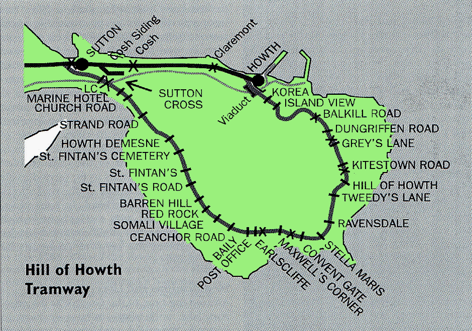
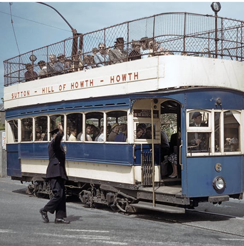
However, by the end of the 19th century, electric traction arrived. On the 17th June 1901 the tram line from Sutton to the Howth Summit was opened, with the final leg of the tram line from the Summit to Howth railway station opening on the 1st August 1901.
The service was run by the Great Northern Railway (Ireland) who saw it as a way to attract more customers to the Sutton and Howth railway stations.
The tram took the scenic route from Sutton railway station up over the south side of the hill to the Summit and then gently down into Howth village terminating at Howth railway station.
On the tram route, there was even a request stop for Earlscliffe.[6] One of the previous tenants mentioned that the tram would drop them off at the Earlscliffe stop and then the driver would wait for them to get safely down to Earlscliffe House and for them to flash the home lights before the tram then headed off up or down the hill.
The trams seated 30 on the lower deck an 45 on the open upper deck. When they were built, they were the largest trams to appear in Dublin. [19]
When the Howth Tram opened in 1901, this was expected to grow the population even further. This growth did happen, but it wasn't because of the tram.
The tram departs
By the early 20th Century, many of the owners of the fine houses being built on the Hill of Howth were starting to own cars, with few using the tram as a regular way to commute. This meant that the tram was mostly used by tourists, and then only during the summer months and dependent upon the weather. With a result, the tram never made any money and was finally closed in 1959. [6]
Before it closed, a gentle film was made of the last journeys of the Howth Tram, called Once upon a Tram. Directed by John Sarsfield and James Maguire, and narrated by Cyril Cusack, the film traces the tram's journey as it moves from Sutton to Howth and back again.
Trams to roads
The increase in car ownership meant that the commute time and journey from Howth into Dublin was seen as acceptable by more people, resulting in a higher population density in Howth as people looked for a little luxury, especially in the 60s and 70s (see graph below). However, this demand required more roads.
On the south side of the hill of Howth at the time of the trams, there had been a road for cars called Carrickbrack Road. However, this was quite a steep and winding road. Once the tram service was stopped, the old track way that the tram ran on that goes past Earlscliffe and up to the Summit was turned into the new Carrickbrack Road, with the old route being renamed Old Carrickbrack Road.
Howth harbour
As for Howth harbour, despite its initial up and down history, it then went from strength to strength. In the mid 1980s, major work took place to transform it from a small fishery harbour to the largest on the east coast. This included an RNLI lifeboat station, a marina and a new middle pier for the fishing fleet.
Population increases
It is interesting to read the population statistics for Howth over the last almost two centuries as they demonstrate the high growth in this period (see graph below). [7]
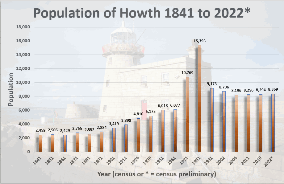
Here are some thoughts on the graph and figures:
- It is interesting that there was no real decrease in the population of Howth during the famine years (1845 to 1850). Maybe this was due to the availability of large quantities of fish? [5] .
- There was a large building programme in Howth and Sutton in the 1970s. In 1980, Professor Vincent McBrierty reported that in the previous eight years, fourteen new streets were created in Howth. [5]
- This increase in housing, and the increase in car ownership, probably led to the booming population in this period.
- However, the decrease in the 1980s was not related to the Pope's visit in 1979 when he preached against contraception! It is more likely that the drop in population was linked to the sharp rise in unemployment at that time, which resulted in mass emigration. [8]
21st Century
In 1999, Fingal County Council recognised the exceptional character of Howth by making the Howth Special Amenity Area Order (SAAO). The Order protects many of the special qualities of the area and aims to preserve and enhance the character and special features of Howth. The Howth Order was confirmed by the Minister for the Environment on 16th May 2000. The Earlscliffe gardens are included in this order. [13]
As the 21st century progresses, Howth population has steadied at over 8,000 people. Even the recession in 2008 didn't seem to affect the numbers.
The harbour has major plans for improvements, with suggested upgrade to the west pier, and works have completed on the middle pier with the "provision of an additional 120 metres of trawler berths".[12]
Other significant events and Howth trivia
Grace O'Malley and Howth Castle
In 16th century Ireland, Grace O'Malley, also known as Gráinne O'Malley or Gráinne Mhaol, became known as the 'Pirate Queen' because of her exploits as a sea-captain and a political activist.
It is said that during a trip to Dublin, Grace went to visit Howth Castle, home of the Earl of Howth, but was told when she got there that the family was having dinner and the castle gates were closed to her. She got so angry at being shut out that she abducted the Earl's grandson and heir, Christopher St Lawrence, and only released him when the Earl promised to keep the gates open to unexpected visitors and to set an extra place at every meal. This arrangement was kept in place until today! [15]
Howth Gun running
On the 26 July 1914, 900 rifles were landed at Howth by Erskine Childers for the Irish Volunteers. Many were used against the British in the Easter Rising and in the subsequent Anglo-Irish War. [1]
Leopold and Molly Bloom
Howth Head is the location where Leopold Bloom proposes to Molly in James Joyce's Ulysses and is mentioned in the lyrics of the title track of Kate Bush's 1989 album, The Sensual World, a song inspired by Molly Bloom's soliloquy in Ulysses:
'.'...took six big wheels and rolled our bodies / off of Howth Head and into the flesh, mmh, yes...'. Kate Bush - The sensual World [4]
For more information
•
•
•
•
•
References
- [1] https://en.wikipedia.org/wiki/Howth
- [2] As discussed in "Howth: A Centenary of Sailing" by WM Nixon, published in 1995 by Howth Yacht Club, Dublin. ISBN 095271440X
- [3] As discussed in "A Guide to Dublin Bay: Mirror to the City" by John Givens, published in 2006 by The Liffey Press. ISBN 1905785089.
- [4] https://en.wikipedia.org/wiki/Howth_Head ,
- [5] As discussed in "The Howth peninsula: Its history, lore & legend", by Vincent J McBrierty, Publisher: North Dublin Round Table (1981) ISBN: 0950755303
- [6] As discussed in "Through Streets Broad and Narrow: A History of Dublin Trams" by Michael Corcoran, published in 2000 by Midland Publishing. ISBN 1857801105
- [7] https://airo.maynoothuniversity.ie/mapping-resources/airo-research-themes/historical-mapping/population-change-1841-2002-dublin seen on 10th Oct 2021.
- [8] As discussed in the article "Baby Boomers" by Brendan Walsh, as seen at http://www.irisheconomy.ie/index.php/2009/06/18/baby-boomers/ seen on 10th Oct 2021.
- [9] As discussed in "Howth And Her Trams: Stories And Sketches Of The Howth Tram" by Jim Kilroy, published in 1986 by Fingal Book Publishers. ISBN 185186010X
- [10] As discussed in "Holyhead Services 1561-2011" eBook, at http://www.thinkscape.ie/stenaline/holyhead_1561-2011.pdf seen on 10th Oct 2021.
- [11] As discussed in http://www.turtlebunbury.com/family/bunburyfamily_lisnavagh/CaptainWillMcCB/bunburyfamily_lisnavagh_captainwill18521866.html
- [12] As discussed in "Major development works planned for Howth harbour " by Mark Hilliard, Irish Times, Jan 18 2018. As seen at https://www.irishtimes.com/news/ireland/irish-news/major-development-works-planned-for-howth-harbour-1.3359208
- [13] See https://www.fingal.ie/howth-special-amenity-area-order
- [14] Taken from https://www.citypopulation.de/en/ireland/dublin/04024__howth/
- [15] See https://visithowth.ie/grace-omalley/
- [16] As discussed in https://afloat.ie/sail/sailing-clubs/howth-yacht-club/item/35740-ireland-s-eye-gives-howth-sailing-a-look-in
- [17] As discussed in https://www.parliament.uk/about/living-heritage/evolutionofparliament/legislativescrutiny/parliamentandireland/collections/ireland/act-of-union-1800/
- [18] As discussed in https://en.wikipedia.org/wiki/Thomas_Telford
- [19] As discussed in "Trams to the Hill of Howth: A photographic tribute" by Jim Kilroy, published in 1998 by ColourBooks ISBN 1898392137
- [20] https://en.wikipedia.org/wiki/Second_city_of_the_United_Kingdom
- [21] https://en.wikipedia.org/wiki/D%C3%BAn_Laoghaire_Harbour
- [22] hhttps://www.dublinportarchive.com/brief-history-of-dublin-port/
- [23] As discussed in "Howth and its Maritime Past" by Kevin Rickard published in Vol. 70, No. 1, Spring / Summer 2017 of Dublin Historical Record published by the Old Dublin Society https://www.jstor.org/stable/i40211741
This page was last updated on 27-Jul-2023.